
Alternative data: setting the record straight on the scale of Indonesia’s 2019 fires
- Written by David Gaveau, Scientist, member of the IUCN Oil Palm Task Force, International Union for the Conservation of Nature
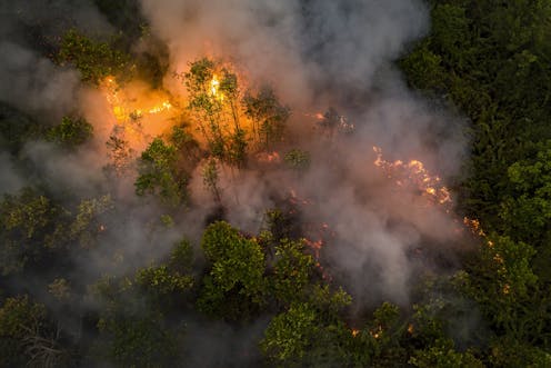
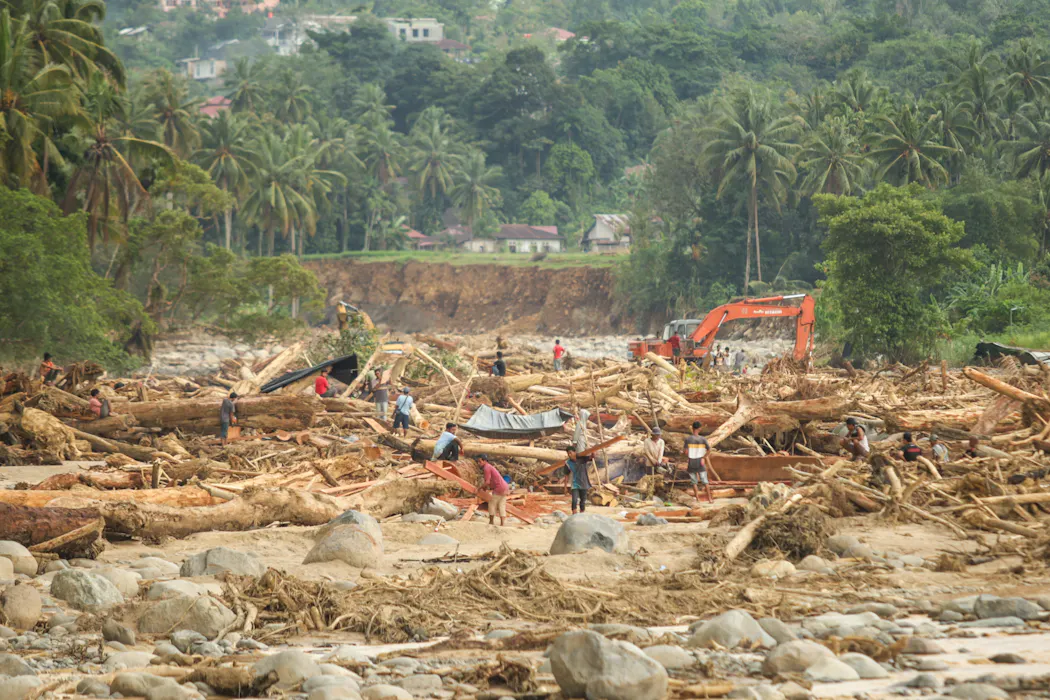
Burning in Indonesia is a sensitive issue. Although fires are scarce in wet intact forest landscapes, they are increasingly frequent in Indonesia’s disturbed forests and peatlands[1].
Not only are fires a concern to the international community due to large-scale carbon emissions[2], but the associated thick air pollution also poses serious health risks[3] to local residents and neighbouring countries.
In January 2020, the Indonesian government deported[4] me for publishing a preliminary estimate of the damage from Indonesia’s 2019 fires for seven provinces that exceeded the government’s own numbers.
The preliminary analysis was entirely based on freely available satellite data, did not require on-the-ground investigations, and I held a valid work permit. However, the government claimed I did not have the right permit to carry out this study. The claim was based on a 2019 science law[5] that tightly restricts research collaborations.
The government also said our findings were invalid[6] because they had not been assessed against ground observations and had not been peer-reviewed.
It is unfortunate that rather than engaging in debate and discussion over the pros and cons of different types of data-gathering and their value, the government chose to kick me out. In doing so, it highlighted the fine line scientists tread when findings contradict the official line.
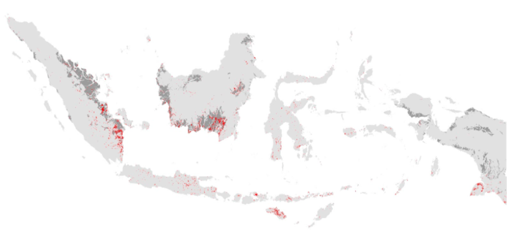
Now, two years later, our analysis has passed the scrutiny of the peer-review process. We have published[7] our findings in the journal of Earth System Science Data, demonstrating that more than 3.11 million hectares of land burned in 2019 across Indonesia’s 34 provinces.
This burned area is double the official estimate of 1.64 million hectares[8] from the Ministry.
A provincial breakdown of burned areas according to our map estimates and those of the official dataset is shown below.
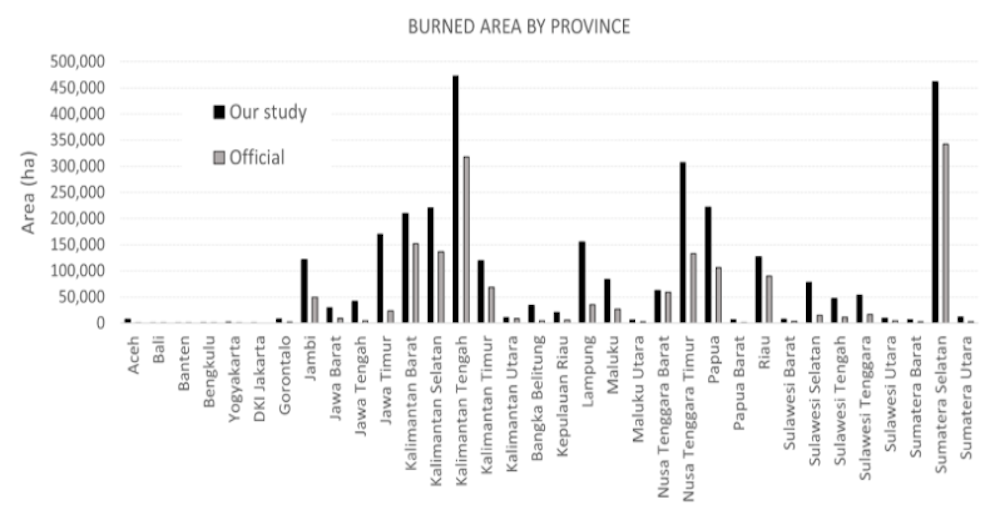 Estimated area of land that burned in 2019 in Indonesia’s 34 provinces, according to our map and the official dataset from the Ministry of Forestry and Environment.
We took a rigorous approach to validating our burned-area map and the equivalent official dataset by measuring them against a carefully designed reference dataset. To our knowledge, no previous data analysis of this type has ever been subjected to such intense scrutiny over Indonesia.
Burning land is illegal in Indonesia. While ground verifications are crucial for forensic analyses of burning across landholdings, and determine who starts the fires, they are less appropriate for a rigorous accuracy assessment.
To measure the errors in the maps, we need extensive randomly distributed, well-characterised reference sites across Indonesia. This process would be too laborious with field visits. Instead, we generated a reference dataset of 1298 random locations based on visual inspection of dense (5 day revisit time) infrared satellite imagery Sentinel-2[9].
All the data including pre- and post-fire images, the burned-area products, and the reference points with screenshots can be visualised at this application portal[10].
This validation resulted in error estimates for both maps. We demonstrated that while they had comparatively low commission errors – meaning every burn scar reported by both maps is valid – our map had a much lower omission error than the official dataset. This means our analysis missed fewer burn scars.
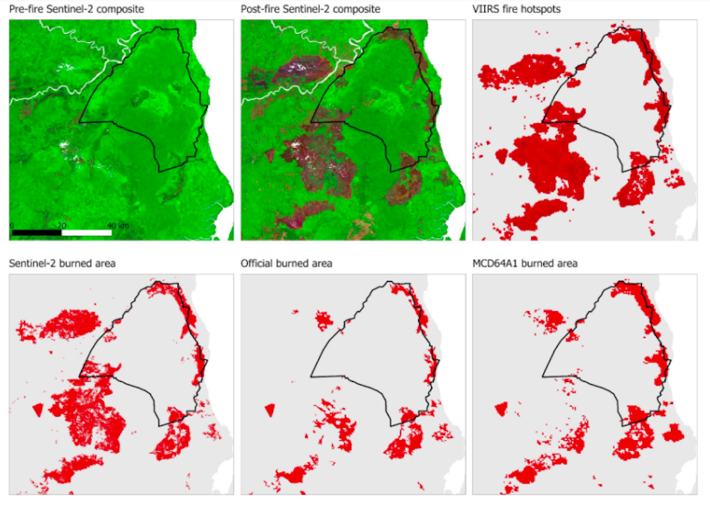 Pre-and post-fire Sentinel-2 images over Berbak National Park (black line) and surrounding areas in Jambi Province, revealing large, burned areas (the areas that have transitioned from ‘green’ to dark ‘brown/red’ tones). These large burn scars have been detected by daily VIIRS hotspots and by the Sentinel-2 burned area map, but some have been missed by the official burned area map from the Ministry of Forestry and Environment and by the global MCD64A1 dataset.
We observed a larger damaged area (3.11 million hectares) because ground-breaking technology enabled us to detect more small burns and more very large ones. We used better satellite data, machine learning and Google’s super-computers.
The official Indonesian estimate relies on a visual interpretation of satellite imagery. This entails a manual delineation of burn perimeters by several interpreters. Our machine-learning detection method is automatic.
Manual computer entries are accurate at small scales, but too time-consuming to produce accurate country-scale data. When delineating small burn scars, so many are missed.
The Landsat[11] satellite underlying the official estimates observed the same area every 16 days. The Sentinel-2 satellite underlying our estimate observed the same area every five days. More frequent acquisitions make it more likely the satellite will take a cloud- and smoke-free image of the ground, and so “see” more burns.
Finally, we analysed the entire archive of Sentinel-2 images over Indonesia thanks to the computing power of the Google Earth engine. In total, we analysed more than 47,000 images. The ministry interpreted a few hundred at best.
Indonesia – along with more than 130 countries – joined the COP26 Global Deforestation Pledge[12] to halt and reverse deforestation by the end of the decade.
Accurate estimates of the areas impacted by fires is vital. This permits scientists and governments to devise policies that properly address concerns about regional air quality and national and international commitments to reduce atmospheric carbon.
The Indonesian government has had some success in reducing deforestation. However, the 2019 burning event indicates that reducing fires remains a challenge. Better protocols would improve the capacity to accurately measure carbon emissions for the country’s climate pledge[13] and other purposes.
As part of the pact made at COP26, a dozen countries committed[14] US$12 billion in public finance from 2021 to 2025. This fund will be funnelled into tackling forest fires, landscape restoration and supporting the rights of Indigenous communities.
Additional commitments from the private sector of $7.2 billion, and pledges to eliminate investment activities linked to deforestation, also form part of the agreement.
The discrepancy in 2019 fires data shows it is vital that financing, grants or funding flows be made conditional on an internationally governed auditing process. Transparency is vital if we are to correct what ails the planet.
References
- ^ peatlands (theconversation.com)
- ^ large-scale carbon emissions (www.carbonbrief.org)
- ^ poses serious health risks (theconversation.com)
- ^ deported (www.science.org)
- ^ science law (science.sciencemag.org)
- ^ our findings were invalid (foresthints.news)
- ^ published (essd.copernicus.org)
- ^ 1.64 million hectares (www.greenpeace.org)
- ^ Sentinel-2 (sentinel.esa.int)
- ^ application portal (thetreemap.users.earthengine.app)
- ^ The Landsat (www.sciencedirect.com)
- ^ COP26 Global Deforestation Pledge (ukcop26.org)
- ^ the country’s climate pledge (drive.google.com)
- ^ committed (ukcop26.org)
Authors: David Gaveau, Scientist, member of the IUCN Oil Palm Task Force, International Union for the Conservation of Nature