

Dune patterns in California desert hold clues that help researchers map Mars’ shifting sands
- Written by Lauren Berger, Ph.D. Student in Geology, Texas A&M University

Our two-person team loaded the car with a GPS, a drone, notebooks, sample bags, a trowel and a flat spatula lovingly called a scoopula. Then we drove 30 minutes in our rented truck from Yuma, Arizona, to the Algodones Dunes[1], a sandy field bordering California, Arizona and Mexico. The day was sunny, with a strong breeze. Turning off the highway, we carefully headed onto a gravelly path that acted as our road.
After making decent – if bumpy – progress, we pulled off onto the sand flats and drove slowly toward the dunes, worried we might get stuck in the sand. Having arrived on the outskirts of the Algodones, we stopped and loaded our backpacks, then set off into the desert on foot.

It was November 2022. As a graduate student at Texas A&M University[2], I was beginning part of my Ph.D. research with my adviser, geology professor Ryan Ewing[3]. We were looking for coarse-grained sand ripples, which are patterned piles of sand shaped by wind. Sand ripples and sand dunes are types of aeolian[4] bedforms, which are wind-created geologic features.
Aeolian bedforms are common on Earth and across the solar system[5], including on Mars, Venus, Pluto, the Saturn moon Titan[6], the Neptune moon Triton[7], and Comet 67P[8]. These geological features, among the first landforms observed by remote images of planetary surfaces, are robust indicators of a world’s wind patterns[9].

Measuring sand patterns in person
The shapes and patterns of aeolian bedforms[10] can reveal the environmental conditions that created them.
Two sizes of the same bedform, such as small dunes on top of big dunes, are called compound bedforms[11]. I study compound bedforms at two scales – the meter- and centimeter-sized coarse-grained ripples at the dunes here on Earth, and the kilometer- and meter-sized dunes on Mars.
At the Algodones, I measured the height of each large coarse-grained sand ripple and the distance between neighboring ripples. Then we flew our drone low and steady, above the ripples, to create high-resolution images. The drone data allows us to do further measurements on the ripples later, back at my desk.
On that day, I learned an essential rule of fieldwork in the desert: Don’t forget a shovel. Otherwise, if your vehicle gets stuck, as ours did, you’ll have to dig it out by hand. Luckily for us, a dune buggy driver passing by helped us out and we were able to get back to Yuma in time for dinner.
 High-resolution drone images of the sand ripples at Algodones.
Lauren Berger
High-resolution drone images of the sand ripples at Algodones.
Lauren Berger
My introduction to Mars
I first became interested in aeolian bedforms during my sophomore year of college, when I interned at the NASA Jet Propulsion Laboratory[12]. My job was to view surface images of Mars and then map the sand ripples in the regions where Perseverance, the Mars rover[13], might land. I assessed the areas where ripples could be hazards – places where the rover could get stuck in the sand, the way our rental truck did in the Algodones.
I mapped those sand ripples[14] on Mars for two years. But while I mapped, I became fascinated with the patterns the ripples made.
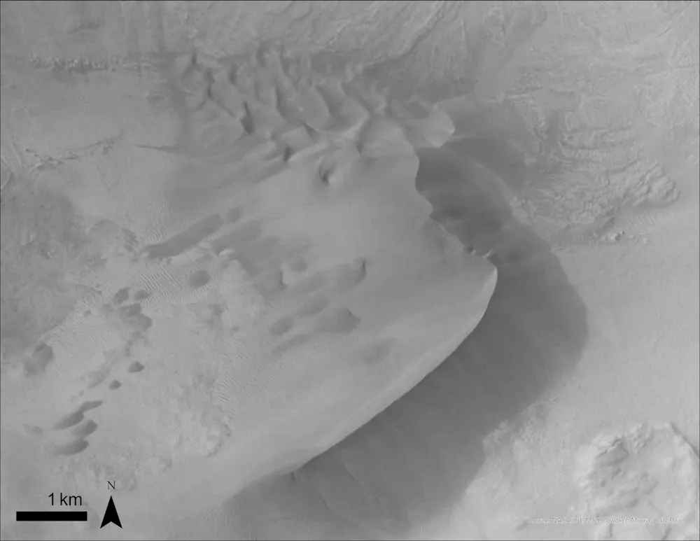 A potential compound dune on Mars.
NASA/JPL-Caltech[15]
A potential compound dune on Mars.
NASA/JPL-Caltech[15]
Now, as a graduate student and aspiring planetary geologist, my time is split between work in the field and at my computer, where I have stitched together the drone’s photographs of the Algodones to create a large image of the entire study area. I then look for compound dunes on the Martian surface in images taken by the Mars reconnaissance orbiter’s[16] context camera[17].
Scientists already know about Earth’s weather patterns, sand grain size and wind data. By measuring different parts of bedforms on both planets – such as their height, shape and spacing – I can compare the similarities and differences of the bedforms to find clues to the wind patterns, grains and atmosphere on Mars. Slowly but surely, as I listen to Studio Ghibli soundtracks, I’m creating the first database of compound dunes on Mars.
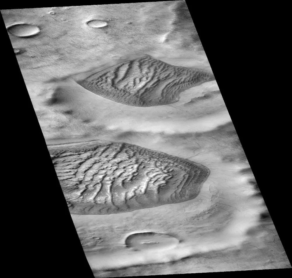 Two dune fields on Mars, both inside an impact crater.
NASA/JPL-Caltech[18]
Two dune fields on Mars, both inside an impact crater.
NASA/JPL-Caltech[18]
Developing this database is essential to the proposed human mission to Mars[19]. Dust storms are frequent, and some can encircle the entire planet[20]. Understanding aeolian bedforms will help scientists know where to put bases so they don’t get buried by moving sand.
It is wonderful to spend an afternoon ping-ponging all over a planet that’s 140 million miles from us, seeing gorgeous terrain while I try to answer questions about the compound dunes on Mars. How common are they? Where do they form? How do they compare to those on Earth? I hope to answer these questions as I work toward earning my Ph.D in geology.
References
- ^ Algodones Dunes (wilderness.net)
- ^ graduate student at Texas A&M University (artsci.tamu.edu)
- ^ geology professor Ryan Ewing (scholar.google.com)
- ^ aeolian (doi.org)
- ^ across the solar system (eos.org)
- ^ Titan (science.nasa.gov)
- ^ Triton (science.nasa.gov)
- ^ Comet 67P (science.nasa.gov)
- ^ robust indicators of a world’s wind patterns (doi.org)
- ^ shapes and patterns of aeolian bedforms (doi.org)
- ^ compound bedforms (doi.org)
- ^ NASA Jet Propulsion Laboratory (www.jpl.nasa.gov)
- ^ Perseverance, the Mars rover (science.nasa.gov)
- ^ mapped those sand ripples (www.hou.usra.edu)
- ^ NASA/JPL-Caltech (hirise.lpl.arizona.edu)
- ^ Mars reconnaissance orbiter’s (science.nasa.gov)
- ^ context camera (science.nasa.gov)
- ^ NASA/JPL-Caltech (viewer.mars.asu.edu)
- ^ human mission to Mars (www.nasa.gov)
- ^ encircle the entire planet (svs.gsfc.nasa.gov)
Authors: Lauren Berger, Ph.D. Student in Geology, Texas A&M University